 Loading... Please wait...
Categories
ARIZONIA WALL MAP
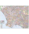
is State of Arizona Wall Map by Kappa Map Group measures 56″ x 60″ and has the following special features and data: all state highways, major waterways, cities & towns, military installations, all federal highways, major airports, state universities, points of interest, cities, state parks, and wildlife areas.
Features
Specs
Other features include color coded counties and a mileage chart between major cities. Provides cartography at a scale of 1” = 8 miles. Printed in color with a markable and washable, laminated surface. Cities, Towns and Places are indexed on the face of the map.
Map is available with the following options:
- Laminated: Laminated for protection on both sides. Use wet erase markers to write on & wipe off.
- Railed: Black plastic framing rails are added on the top and bottom of your Laminated map for easy wall mounting.
- Spring roller: A Spring roller is applied to a Laminated map to turn it into a pull down map.
- Spring roller/Backboard: Laminated map is attached to spring roller and we provide backboard and all components to mount
Current Top Sellers
-
1

-
2

-
3

-
4
-
5

New Products
-

$19.95$17.95
-
 $19.99
-
 $19.95
-
$279.00$249.00
-
$49.00